Wandering waters
Rain has pelted the region continually in recent days, accompanied by outdoor implications. On the ãupã side, a wet spell in spring causes morels to pop, and a lot of kayaks on cars have been heading for the mountains. High water has its dangers, but it also allows paddlers to navigate smaller creeks they normally canãt run. Negatives of this drenching include most trout streams staying too high and stained to fish, and wet cold weather now is tough on survival of fledgling birds, especially ground-dwellers like wild turkeys and ruffed grouse, and our declining grouse need no additional hits.
With water flowing everywhere, itῧòÆóç natural to wonder where it all goes. Here in Fayette County, itῧòÆóç not as simple as it may seem.
ItῧòÆóç a fact that every square inch of Fayette County falls within the watershed of the Monongahela River, meaning that any drop of rain falling within the county finds its way to the ãPointã in Pittsburgh via the Mon, and then onward and downward, of course, to the Ohio, Mississippi, and Gulf of Mexico. But raindrops falling in various places take different routes to meet the Monongahela. ItῧòÆóç like water poured on top of an overturned bowl, flowing away from the peak in all directions.
Rain falling on roughly the western third of the county, centered on Uniontown but excluding Point Marion, takes the simplest route to the river. All runoff there flows directly west to the Mon via the major sub-watersheds of Georges Creek, Dunlap Creek, and Redstone Creek. Smaller, some un-named, creeks in the extreme west around communities like East Millsboro, Isabella, and Adah fall directly into the Mon without joining one of the larger streams named above.
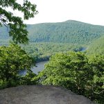
If you drew a squiggly diagonal line, connecting high points, across the county from Arnold City in the northwest to Markleysburg in the southeast, ever drop of rain falling east or north of that line reaches the Monongahela by first being part of the Yough. That vast swath accounts for about half the county, centered on Connellsville. Within it, the Youghiogheny pulls in all drainage from Rte. 40 in the south to the countyῧòÆóç northern border near Bear Rocks and Champion. Major sub-watersheds feeding the Yough are Meadow Run and Dunbar Creek, both flowing northward to the river, Indian Creek, flowing south to meet the Youghiogheny in the wilds between Ohiopyle and Connellsville, and Mounts Creek, flowing southwest along the base of Chestnut Ridge in Bullskin Township. In the extreme southeast, small streams like Tub Run and Ramcat Run tumble directly into the Yough.
But even the YoughioghenyῧòÆóç drainage is not that simple. North of a rough line connecting White, in the mountains, with the lowland communities of Everson, Owensdale, and Layton, a narrow strip of Fayette drains northward to Jacobs Creek, which forms the border with Westmoreland County. Jacobs CreekῧòÆóç upstream beginning, by the way, is that cascading stream you see stair-stepping off the mountain to the right of the Turnpike as you ascend Chestnut Ridge headed east toward Donegal.
Far downstream, Jacobs Creek joins the Yough just upriver from Smithton, reuniting rain that fell on either side of the divide. The Youghiogheny, then, continues northwest to enter the Monongahela at McKeesport, where runoff from all over Fayette County reunites after taking different routes to get there.
Some of that re-gathering water, though, took an even more roundabout path. Roughly 15 percent of the countyῧòÆóç extreme south, from Dividing Ridge at Markleysburg west to Point Marion drains southward into the Cheat River, that storied, sometimes brawling stream that originates in mysterious places like Canaan Valley and the Otter Creek Wilderness in West Virginia, then joins the Monongahela at Point Marion, Pennsylvania.
Mostly, Fayette CountyῧòÆóç Cheat River watershed forms a narrow strip along the Mason-Dixon Line, but it reaches far northward at the center by virtue of Big Sandy CreekῧòÆóç headwaters. HereῧòÆóç an interesting geographic tip. As you climb toward the crest of Summit Mountain on Rte. 40, headed west toward Hopwood and Uniontown, glance to the right (north) just before the top. That little pond tucked into the hollow is the very beginning of Big Sandy Creek. From there it runs south, under Rte. 40, then drains a big basin past Wharton Furnace, Elliotsville, Quebec Hollow, and Bruceton Mills, headed for the Cheat River near Coopers Rock.
That attractive lake along Rte. 40 at Chalk Hill also drains to Big Sandy and the Cheat. But, interestingly, if you turn at the Chalk Hill stoplight and go just a half-mile north to Deer Lake, its outflow becomes Meadow Run and drains north to the Youghiogheny. If you turn left (west) at Deer Lake on Greenbrier Road and go another mile youãll cross streams flowing west to Dunbar Creek. That remote heart of the county is the top of the ãoverturned bowl.ã
You must go to the far western reaches of Greene County to escape the MonongahelaῧòÆóç pull. As you leave Waynesburg headed west on Rte. 21, the roadside streams flow against your progress, eastward back toward the Monongahela via Tenmile Creek. But at about Graysville, youãll notice the streams are suddenly flowing with your direction of travel. That water gathers around Ryerson Station State Park into the Dunkard Fork of Wheeling Creek, flowing west directly to the Ohio River at Wheeling, West Virginia, bypassing the Monongahela altogether.
A grasp of the regionῧòÆóç watersheds can be an asset to anglers and boaters, if only in understanding where we are enjoying the outdoors within the larger landscape.
Ben Moyer is a member of the Pennsylvania Outdoor Writers Association and the Outdoor Writers Association of America.